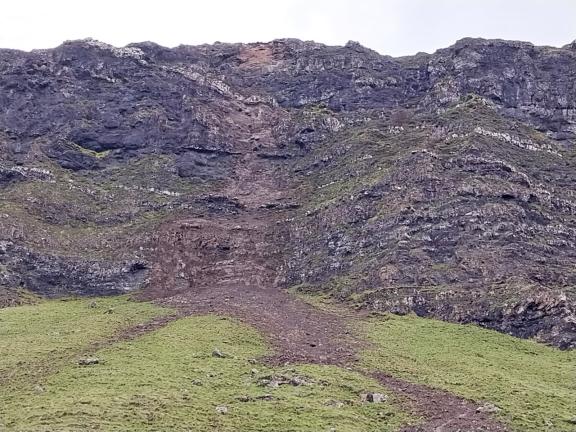
Following the first of three recent rockfalls of a section of rock outcrop above the public road at Gribun in early July 2025, the B8035 on the Isle of Mull was closed to vehicles. This was to ensure the safety of public travelling on this part of the public road network for which Argyll and Bute Council is responsible. A second rockfall occurred in early August and a third in late September.
Update 26/11/25
Stage 3 of this Geotechnical Risk Management ran from 13/10/2025 to 17/11/2025 and included:
- Development of mitigation options by specialist consultant,
- Submission of Final Options Report to Council by specialist consultant,
- Council appraisal of Final Options Report,
- Revision of Final Options Report to Council by specialist consultant,
- Submission of revised Final Options Report to Council by specialist consultant,
You can read the Final Options Report
Key extracts from the Final Options Report are:
Executive Summary
This report presents the final appraisal of geotechnical risks and mitigation options for the B8035 at Gribun, Isle of Mull, following recent rockfall incidents that have impacted the carriageway and posed significant safety risks to road users.
An updated quantitative risk assessment has been presented, further considering the impact of reducing the number of journeys, or reducing the frequency of rockfall events impacting the road. This updated QRA indicates that for a high frequency of events (e.g. 10 blocks per year), journeys would need to be reduced to below 20 journeys per day for single occupancy vehicles to reduce the risk to within the ALARP (As Low As Reasonably Practicable) region, and that for multi-occupancy vehicles the risk remains unacceptably high.
Potential remediation options including operational measures, and engineering interventions have been presented. Full slope engineering interventions are likely to result in the greatest risk reduction, however many of these interventions are likely to be time consuming, and present significant costs and technical challenges.
Targeting interventions to areas that potentially present higher risk, such as sections where sightlines are reduced, or there is potentially a higher frequency of rockfall events depositing on the road may reduce the level of risk to within the ALARP or acceptable levels in a more cost-effective manner.
Conclusion (page 21):
This final options report presents an updated assessment of the geohazard risks posed to users of the B8035. The updated hazard modelling, incorporating RAMMS rockfall modelling and site-specific observations, confirms that the likely frequency of rockfall events pose a risk level that is probably on the boundary of Tolerable / Unacceptable regions but under certain conditions / circumstances is likely to move into the Unacceptable level of risk, especially in areas that may have higher rockfall frequency, or where the cliff face is directly adjacent to the carriageway with reduced lines of sight.
The Quantitative risk assessment is preliminary and there are a number of factors that have been simplified, such as annual rockfall frequency and some factors such as drivers reaction to break or avoid fallen rocks that have not been taken into account.
Mitigation options which are likely to reduce the level of risk to an acceptable or ALARP level have been presented in Table 3-2. To take the project onto the next stage we recommend that Argyll and Bute Council undertake a review and determine the most appropriate two remedial options or combined options (e.g. signage and scaling of specific areas) that manage their risks at a tolerable level. These two options could then be progressed further to enable a budget to be set for the project, and detailed consultation with appropriate stakeholders. The most beneficial option, in terms of cost, programme, and risk reduction could then be taken forward to the next stages of implementation.
Given the nature of the findings in the Final Options Report, the road must continue to remain closed for the following reasons:
- Further potential failures have been identified.
- The risk to road users is calculated as unacceptable according to Health and Safety Executive (HSE) standards.
- Intervention is required before the road can be safely reopened.
The following constraints identified within the Final Options Report regarding the Mitigation Options (pages 18-19) are noted:
- The low effectiveness of the following Options:
- Reopening with additional signage,
- Road closure during rainfall events,
- The high estimated costs of the following Options:
- Rockfall Fences (whole slope or targeted),
- Rock Stabilisation (whole slope or targeted),
- Scaling (whole slope or targeted),
- The constructability issues of the following Options:
- Earthwork Bund,
Stage 4 will consist of the following steps being progressed:
- Determine the most appropriate remedial options or combination of options that manage the risk at a tolerable level.
- Review appropriate remedial options to identify most beneficial option, in terms of cost, programme, and risk reduction best option.
- Secure necessary funding for the most beneficial option.
- Take forward the most beneficial option to be implemented under Stage 5.
Update 13/10/2025
Specialist Geotechnical consultant, AtkinsRéalis, has provided the Interim Appraisal as part of Stage 2 of the Geotechnical Risk Management Assessment.
Key extracts from the Interim Assessment are:
Executive Summary (page 5):
“Recent assessment of the B8035 at Gribun, Isle of Mull, has identified significant rockfall hazards. These arise from steep basaltic cliffs with both unweathered and weathered units, where erosion and structural weaknesses have led to recent failures impacting the carriageway. Further potential failures of a similar size have been identified.
“The resultant risk to road users is calculated as unacceptable according to Health and Safety Executive (HSE) standards, with estimated fatality rates exceeding the tolerable threshold. This means intervention is required before the road can be safely reopened.
“Potential remedial options include management measures such as continued closure and limited access, as well as engineering interventions like rock bolting, barriers and mesh installation. However, these present logistical and financial challenges due to the site’s scale.
“The final report will deliver a detailed risk assessment, incorporate results from ongoing rockfall runout modelling, and present a detailed appraisal and cost-benefit analysis of mitigation strategies.”
Interim conclusions and recommendations (page 23):
“Our interim assessment, prior to modelling concludes that the current level of risk posed to users of the B8035 within the considered site area is classified as unacceptable. Therefore, before the road can be reopened to the public mitigation measures must be put in place to reduce the level of risk to an tolerable level.
“As stated in CIRIA C810 (Koe, et al., 2023), mitigation strategies fall into two broad categories: management measures and engineering works. Avoidance measures such as closure of the road to the public, except for access to local properties, would allow for the overall risk to be lowered due to the significant reduction in traffic reducing the total exposure to rockfall risk. Inspection of the rock face and scaling of loose and overhanging blocks would reduce risk by reducing the number of rockfall events impacting the road. However, due to the scale of the site this option would be challenging.
“Engineering interventions such as rock bolting of loose blocks, barriers, or the use of mesh to control material falling from the face would reduce the risk by reducing the frequency of rockfall reaching the road. However, due to the large scale of the rock faces on site, these solutions are likely to take a significant amount of time to implement at “significant expense. Further assessment of potential remedial options and a cost-benefit analysis will be presented within the final options report.
“The next report will deliver a final risk assessment, incorporate results from ongoing rockfall runout modelling concentrated in the area where a large rockfall occurred recently and further potential failures have be identified, and present an appraisal and cost-benefit analysis of mitigation strategies.”
Given the nature of the findings in the Interim Appraisal / Assessment Stage (Stage 2), the road must remain closed for the following reasons:
- Further potential failures of a similar size have been identified.
- The risk to road users is calculated as unacceptable according to Health and Safety Executive (HSE) standards, with estimated fatality rates exceeding the tolerable threshold.
- Intervention is required before the road can be safely reopened.
Stage 3 of this Geotechnical Risk Management will run from 13/10/2025 to 17/11/2025 and shall include:
- Development of mitigation options. Options will range from low-cost interventions (e.g. signage only, stopping-up of road) to engineered solutions (e.g. rock netting, catchment areas, attenuator fencing).
- Final report submitted to the council by the consultant.
- Council appraisal of final report.
- Decision on any further actions able to be taken at final report stage.
- Final report update and details of any further actions able to be taken following a review by Roads and Infrastructure Services.
Update 01/10/2025
Specialist Geotechnical consultant, AtkinsRéalis, carried out a site visit yesterday (Tuesday 30th September) and have provided the following statement:
“Following our site inspection yesterday, AtkinsRéalis has identified a significant risk of further rockfall at the top of the cliff in the region of the recent failure. Given the poor weather forecast for the next seven days, there is an elevated risk of additional rockfall along this closed section of the road.
It's important to note that the public had cleared the rock and debris from the previous event and are using the road despite the road closure, which means they are placing themselves and others at risk.
The site visit also identified a rockfall risk across the wider 1.8km that was inspected. ”
Due to the forecast Yellow Warning rainfall events over the coming days it is particularly important that the road closure is fully complied with by the travelling public.
The closure of this section of the B8035 at Gribun is necessary to protect the travelling public from what (until a Geotechnical Report is available) is categorised as a risk to life. As notified by the consultant, it appears that road users have again removed the traffic management at the road closure – and that the barriers had been moved from their position of closing the road. Not only does this pose a risk to road users themselves, but anyone approaching the road closure (particularly those not familiar with the area) may be unaware that the road is closed for public safety. This is a recurrence of what was found and reported on 16 August 2025. Police Scotland have again been made aware.
Details of the Order which legally closes the road can be found on TellMeScotland:
We would again remind all road users that the road has been closed due to three recent rock falls, which have caused significant damage to the road surface, the safety barrier and the hillside itself. Driving on this section of road, or enabling and encouraging others to do so, presents a risk to life.
Update 26/9/2025
The Council arranged for a drone survey of the area to be carried out in August.

A specialist consultant was engaged in mid-September to carry out Geotechnical Risk Management Assessment of the area. The full outcome of this work is expected to be ready in mid-November 2025. The stages of the Geotechnical Risk Management Assessment are:
Stage 1 (27/08/2025 to 19/09/2025) - completed
- Tendering of Geotechnical Risk Management contract to specialist consultants.
- Contract Award to specialist consultant.
Stage 2 (27/08/2025 to 27/10/2025) – currently underway
- Site inspection, data acquisition and drone survey (site based).
- Risk assessment and rockfall trajectory modelling (office based).
- Preliminary, Interim Appraisal submitted to Council. This will summarise preliminary findings and outline emerging options. The specialist consultant will progress to Stage 3 at this point.
- Council evaluation of Interim Appraisal.
- Decision on any further actions able to be taken at Interim Appraisal stage.
Stage 3 (13/10/2025 to 17/11/2025)
- Development of mitigation options. Options will range from low-cost interventions (e.g. signage only, stopping-up of road) to engineered solutions (e.g. rock netting, catchment areas, attenuator fencing).
- Final Report submitted to Council by consultant.
- Council appraisal of Final Report.
- Decision on any further actions able to be taken at Interim stage.
- Final Report update and details of any further actions able to be taken following RIS review.
Stage 4 (17/11/2025 onwards)
- Taking forward of selected option.
Throughout the process we have worked with the National Farmers Union (NFU) to find a way to support the farming community as we understand there are real challenges presented by the road closure. To try and mitigate these, we are investigating exemptions that can be made to the TRO on the diversion road to provide solutions to agricultural feed requirements during the closure.